BS Remote Sensing and GIS: Scope and Salary in Pakistan (2026)
What is the real BS Remote Sensing and GIS scope in Pakistan, and what does the degree pay? For most students weighing it up, those are the first two questions.
The short answer is yes, there is scope, but it is a specialised field rather than a mass-market career like computer science or business. The strongest opportunities sit in urban planning, surveying and mapping, agriculture, water resources, disaster management, environmental monitoring, telecommunications, infrastructure, defence applications and satellite-based earth observation.
What GIS pays in Pakistan
| Career stage | Approximate monthly salary | Typical profile |
|---|---|---|
| Internship / trainee | Rs. 20,000–40,000+ | Basic GIS, mapping, data preparation |
| Junior GIS professional | Rs. 40,000–70,000+ | 0–2 years, ArcGIS/QGIS, basic analysis |
| GIS Analyst / Executive | Rs. 60,000–100,000+ | Strong spatial analysis, professional experience |
| Experienced GIS Specialist | Rs. 90,000–150,000+ | Advanced GIS, databases, remote sensing |
| Senior / technical specialist | Rs. 120,000–250,000+ | Advanced skills, project responsibility |
| Project lead / highly specialised | Rs. 200,000+ | Leadership, major projects |
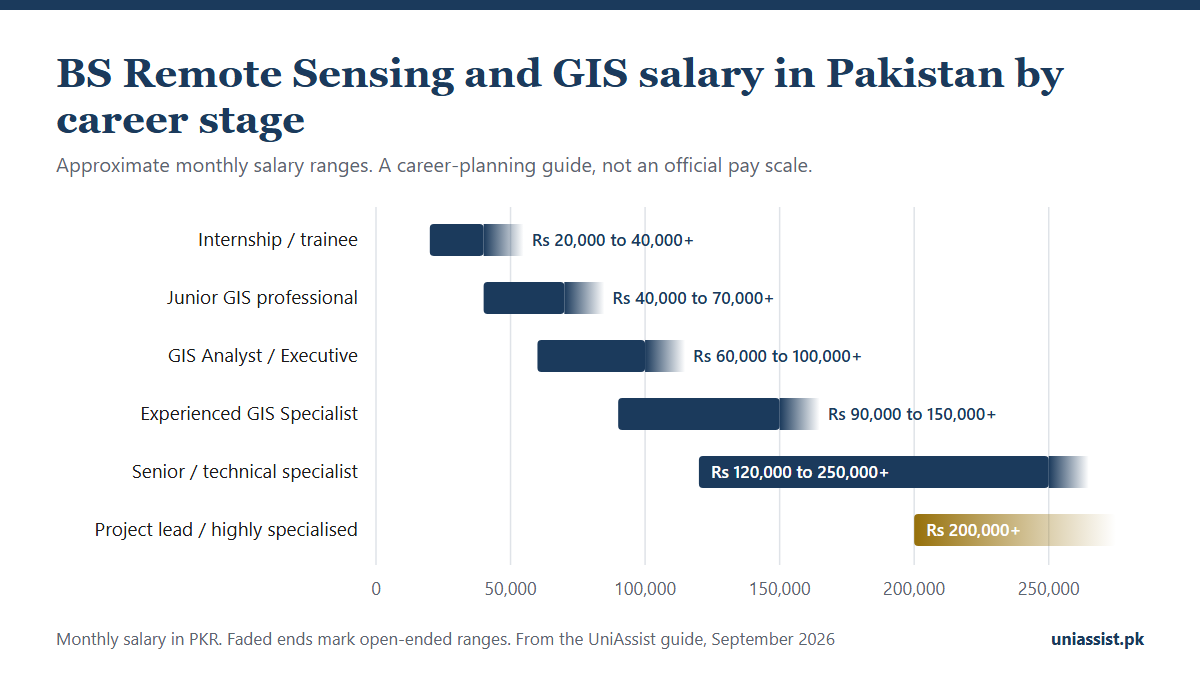
Treat this as a career-planning guide rather than an official salary scale. The ranges are deliberately broad, because the Pakistani GIS market is not standardised enough for one number to apply across every employer. The published salary data behind them appears further down, with its sources and its sample sizes.
One condition is worth stating early. A graduate who only knows basic map-making may struggle. Someone who combines GIS with Python, SQL, remote sensing, spatial analysis, databases and Web GIS can build a considerably stronger career.
What is BS Remote Sensing and GIS?
Remote Sensing and Geographic Information Systems are closely related, but they are not the same thing.
GIS collects, manages, analyses and visualises information tied to locations on the Earth’s surface. A GIS professional might produce a map showing roads, schools, hospitals, electricity networks, flood-prone areas or land use.
Remote sensing obtains information about the Earth’s surface without surveying every location directly. Satellite imagery, aerial photography, drones and LiDAR are used to observe changes in land, vegetation, water, infrastructure and environment.
The two complement each other. A remote sensing specialist might obtain imagery showing changes in agricultural land. A GIS analyst then combines it with boundaries, roads and irrigation networks to produce something a planner can act on.
Pakistan’s Higher Education Commission revised the national Remote Sensing and GIS curriculum in 2025, covering Associate Degree, BS and MS levels, with the stated aim of bringing it closer to industry needs and international standards.
Source: HEC: Revised Curriculum for Remote Sensing and GIS
Where you can study it
Five universities in the UniAssist directory currently offer this degree:
- Bahria University
- University of Gujrat
- Mir Chakar Khan Rind University of Technology, Dera Ghazi Khan
- Government College University, Lahore
- Kinnaird College for Women
Entry requirements, duration and fees where published are on the programme page. Related routes include BS Geoinformatics Engineering, and at postgraduate level MS Remote Sensing and GIS and PhD Remote Sensing and GIS.
Is it a good degree?
For the right student, yes, provided the expectations are realistic.
This is not the degree to pick if the only goal is maximising job openings on graduation. The GIS market is considerably smaller than software development, accounting or conventional engineering.
Its advantage is breadth. GIS professionals work across urban and regional planning, land and property mapping, agriculture and crop monitoring, water resources, flood and disaster mapping, environmental monitoring, forestry, telecoms and fibre-network planning, transportation, surveying, geospatial databases, Web GIS, defence mapping, climate studies and research.
The field is also moving beyond traditional cartography into databases, programming, automation, cloud systems, AI and machine learning. SUPARCO’s current training programme includes machine learning in remote sensing, AI-powered geospatial solutions, Web GIS, optical and SAR data, and climate-induced disaster monitoring. That is a fair indication of where the field is heading.
Sources: SUPARCO Short Training Courses · SUPARCO: Machine Learning in Remote Sensing
GIS salary in Pakistan, in detail
Salary is an area where a single number misleads. Pay varies by experience, city, employer, technical skill, and whether the role is basic mapping or specialised technical work. The available data also comes from small samples, so the figures below are market indicators rather than guarantees.
Indeed reports an average base salary of approximately Rs. 59,610 per month for GIS Analysts in Pakistan, based on three reported salaries, with a typical range of roughly Rs. 36,451 to Rs. 97,485. Indeed’s historical company data also lists NESPAK at approximately Rs. 752,000 per year. That figure is salary information Indeed has collected, not an official NESPAK scale.
Source: Indeed: GIS Analyst Salary in Pakistan
Job advertisements are firmer evidence. An Islamabad Executive GIS position advertised in 2026 offered Rs. 90,000 per month for a bachelor’s degree plus 2–3 years of experience, and specifically required ArcGIS/QGIS, cartography, spatial analysis, geospatial data management, SQL, Python and data visualisation. That listing makes a wider point: employers increasingly want GIS professionals who can do more than produce maps.
Source: Indeed: Executive GIS Job in Islamabad
For comparison, Indeed’s GIS Specialist page reports Rs. 92,442 per month in Islamabad, though that estimate rests on only two reported salaries and was last updated in 2025. Glassdoor puts the median total pay for GIS Analysts in Pakistan nearer Rs. 58,000 per month. The distance between those sources is exactly why the table above uses bands instead of a figure, and why it is worth checking several sources rather than trusting one salary website.
Sources: Indeed: GIS Specialist Salary, Islamabad · Glassdoor: GIS Analyst Salaries in Pakistan
What moves a GIS salary
Two graduates with the same degree can end up far apart. The difference is usually technical capability.
GIS software. ArcGIS Pro and QGIS remain the core tools, alongside spatial analysis, geoprocessing, cartography, coordinate systems, raster and vector data, geodatabases, GPS/GNSS data and map production. Knowing the buttons is not the skill. Solving a problem with them is.
Python and automation. Automating repetitive operations, processing large datasets, working with APIs and building data-processing workflows. This is the single easiest way to move beyond mapping work.
SQL and spatial databases. SQL, PostgreSQL and PostGIS open the door to more technical positions, particularly where GIS integrates with enterprise systems. SUPARCO’s advanced Web GIS course covers exactly this ground.
Source: SUPARCO: Modern WebGIS using Open Source Technologies
Remote sensing. Image classification, change detection, multispectral imagery, SAR, NDVI and vegetation analysis, land-cover mapping, digital elevation models and Google Earth Engine.
Domain knowledge. GIS with agriculture leads to crop monitoring. With civil engineering, to infrastructure mapping. With telecoms, to fibre-network planning. With disaster management, to flood and vulnerability mapping. With environmental science, to climate and water monitoring.
Career paths
GIS Analyst. Spatial analysis, map preparation, spatial queries, database maintenance and reporting. The most common entry route.
GIS Specialist. Database management, system administration, automation, Web GIS and specialised industry applications.
Remote Sensing Specialist. Satellite, aerial and drone imagery applied to agriculture, forestry, climate monitoring, disaster assessment, geological mapping, urban growth and land-use change.
Cartographer. Map design and production, now heavily digital.
Geospatial Developer. The most technical route, combining GIS with Python, JavaScript, SQL, PostGIS, APIs, GeoServer, Leaflet, Mapbox and cloud platforms.
Survey and Mapping Professional. Surveying, GPS/GNSS, photogrammetry and drone work. Survey of Pakistan’s Photogrammetry and Remote Sensing Directorate works with satellite imagery, UAVs, LiDAR and digital photogrammetry across city, dam, border and cadastral mapping.
Source: Survey of Pakistan: Photogrammetry & Remote Sensing
Who hires in Pakistan
There is no single “GIS industry” here. Professionals are spread across government departments, engineering consultancies, development organisations, utilities, telecoms and technology companies.
SUPARCO operates the National Center for Remote Sensing and Geo-Informatics and runs training in satellite remote sensing and GIS. Pakistan’s National Space Policy identifies applications across agriculture, health, land, environment, disaster management, surveying and navigation. A BS does not imply a job there. Recruitment is competitive and vacancies vary.
NESPAK is the clearest example of GIS embedded in large engineering work: satellite-based crop-water monitoring, drone imagery, photogrammetry, Web GIS, GIS databases and field data collection, across more than 60 GIS-sector projects. Its Geomatics work adds LiDAR mapping, 3D laser scanning and land management.
Source: NESPAK: GIS and Geospatial Services
WAPDA has advertised a GIS/MIS Specialist position, so geospatial skills do feature in its water, hydropower and irrigation work. Do not assume a fixed salary, because public-sector pay depends on the advertisement, the grade and the terms of appointment.
Source: WAPDA: GIS/MIS Specialist Application Form
Survey of Pakistan, NDMA and the provincial disaster authorities, telecommunications companies doing fibre-network planning, route surveys and infrastructure mapping, and engineering consultancies working on roads, dams, irrigation, water supply, environmental assessment and flood modelling round out the market.
Source: NDMA: Geospatial Technologies
BS Remote Sensing and GIS scope in Pakistan: the job market today
The market is real but specialised. Current listings include GIS Technician, Executive GIS and GIS Analyst roles, and a 2026 Geospatial Reasoning Specialist post connected to AI training, which suggests geospatial work is starting to overlap with machine learning. Government listings in 2026 included Assistant Director Remote Sensing, Assistant Director Image Processing and GIS Assistant posts with the Punjab Forest Department.
Sources: Indeed: Remote Sensing and GIS Jobs · Jobz.pk: Remote Sensing Jobs
GIS work is not always advertised as “GIS”. Searching that term alone misses roles titled Geospatial Analyst, Geospatial Specialist, Remote Sensing Analyst, GIS Developer, GIS Technician, Mapping Specialist, Spatial Data Analyst, Geomatics Specialist, Survey Specialist, Cartographer, Photogrammetry Specialist, Earth Observation Analyst and Spatial Database Specialist.
Working remotely or abroad
Possible, but it depends on the skill set. Basic digitisation and simple map production are easy to outsource, so international competition is strong. Specialised skills travel much better: Python with GIS, SQL and PostGIS, remote sensing, Google Earth Engine, machine learning, Web GIS, spatial data engineering, LiDAR, photogrammetry, drone mapping and cloud GIS.
Honest advantages and drawbacks
In favour. The degree is genuinely interdisciplinary. Location data matters more to businesses and governments every year. It suits geography students who also like computers and analysis, there is room to specialise, and strong technical skills carry real international potential.
Against. The job market is small next to software engineering. Starting salaries can be modest. Software knowledge alone is not enough. Some roles involve substantial fieldwork. Government employers such as SUPARCO, WAPDA and Survey of Pakistan are attractive but competitive, with limited vacancies.
How to improve your prospects
Do not spend four years only completing assignments. Build a portfolio of real projects: a land-use classification from satellite imagery, a flood-risk map for a Pakistani city, a crop-monitoring project, a Web GIS application, a PostGIS database, a Python automation project, a Google Earth Engine analysis, a drone or photogrammetry project, an urban-growth study.
The useful combination is GIS + Remote Sensing + Python + SQL/PostGIS + Web GIS + Data Analysis. Start with GIS fundamentals and add the rest gradually.
GIS or a general Geography degree?
For a student specifically interested in technology and spatial data, BS Remote Sensing and GIS is a more directly technical route into spatial analysis, remote sensing, GIS software, geospatial databases and satellite imagery.
That does not make BS Geography, offered by eight universities in our directory, a weaker choice. Geography graduates move into GIS through postgraduate study and practical experience. The distinction is specialisation, not quality.
The verdict
BS Remote Sensing and GIS is worth considering for students who genuinely enjoy geography, technology, data and spatial problem-solving.
It is a poor choice if the expectation is an easy government job at SUPARCO or WAPDA. Those posts exist, but they are limited and competitive.
The better strategy is broader. Learn GIS properly, add remote sensing, learn Python, understand SQL and spatial databases, build Web GIS applications, work with satellite imagery, and develop a portfolio around real Pakistani problems. That turns “someone who makes maps” into a geospatial analyst, remote sensing specialist, GIS developer or spatial data analyst.
Pakistan’s own institutions show the work is already being done at a serious level. SUPARCO is expanding training around remote sensing and AI, NESPAK applies GIS across engineering and environmental projects, Survey of Pakistan works with photogrammetry and LiDAR, and WAPDA has recruited GIS specialists.
The scope is real. The strongest opportunities go to graduates who treat GIS as a technology career rather than a mapping subject.
Explore all programmes, universities by city and province, or work out your aggregate with the merit calculator.
Frequently Asked Questions
What is the salary of BS Remote Sensing & GIS in Pakistan?
There is no single figure, because pay depends on the role. A 2026 Islamabad Executive GIS advertisement offered Rs. 90,000 per month for a graduate with 2–3 years of experience. Indeed's GIS Analyst average is around Rs. 59,610 per month, drawn from three reported salaries, and Glassdoor's median is near Rs. 58,000. Experienced and specialised roles go considerably higher.
Is there scope for GIS in Pakistan?
Yes. GIS is used in engineering, urban planning, agriculture, disaster management, water resources, telecommunications, environmental monitoring, surveying, government planning and satellite applications. The scope is strongest for graduates who combine GIS with programming, databases and remote sensing.
Which universities offer BS Remote Sensing & GIS?
Five in our directory: Bahria University, University of Gujrat, Mir Chakar Khan Rind University of Technology (Dera Ghazi Khan), Government College University Lahore, and Kinnaird College for Women. See the [programme page](/programs/bs-remote-sensing-and-gis/) for entry requirements and fees, and confirm HEC recognition and the current intake with the university before applying.
Can GIS graduates work remotely or abroad?
Yes, particularly with advanced skills in remote sensing, Python, spatial databases, Web GIS, Google Earth Engine and geospatial development. Basic mapping work faces heavy international competition.
Is GIS a good career for the future?
Location data is fundamental to a widening set of industries, so the field should stay relevant. The future GIS professional is likely to be more technical than the traditional cartographer, with programming, databases, remote sensing and automation mattering more each year.